


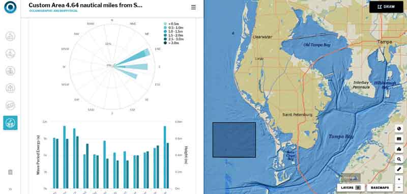
A new web-based interactive tool for ocean mapping and planning created by NOAA and the Department of the Interior’s Bureau of Ocean Energy Management (BOEM), is giving everyone from ocean industries to coastal managers, students, as well as the general public the opportunity to be an ocean explorer from their own computer.
The new OceanReports web tool, available at http://www.marinecadastre.gov/oceanreports/, provides users specialized “ocean neighborhood analyses” including maps and graphics by analyzing more than 100 ocean datasets instantaneously.
U.S. ocean waters comprise nearly four million square miles and is one of the largest Exclusive Economic Zones (EEZ) in the world.
What is the EEZ?
The exclusive economic zone is the zone where the U.S. and other coastal nations have jurisdiction over natural resources

The U.S. Exclusive Economic Zone (EEZ) extends no more than 200 nautical miles from the territorial sea baseline and is adjacent to the 12 nautical mile territorial sea of the U.S., including the Commonwealth of Puerto Rico, Guam, American Samoa, the U.S. Virgin Islands, the Commonwealth of the Northern Mariana Islands, and any other territory or possession over which the United States exercises sovereignty.
Now, when users outline any area in the U.S. EEZ using the OceanReports tool, they can get detailed information about habitats and species, industries in the area, potential hazards such as undersea cables or shipwrecks, economic value of ocean commerce, and other detailed oceanographic information.
“The world’s largest collection of ‘ocean intelligence’ can now be accessed to help sustain and grow one of the world’s largest blue economies,” said Neil Jacobs, Ph.D., acting NOAA administrator.
“Whether it’s aquaculture siting, marine transportation, or offshore energy, OceanReports puts this data at our fingertips and gives us an edge as we continue to grow our national economy.”

OceanReports builds on more than a decade of data collection to transform how seemingly disparate ocean information can be delivered to the nation’s ocean and coastal industries, which add $320 billion in gross domestic product to the nation’s economy.
And while OceanReports provides a fountain of data for use by industry and science, it’s still easy enough to use in the classroom to help students studying biology, chemistry, geography and even other disciplines like economics.

“With such a diverse range of ocean uses and stakeholders, the OceanReports tool greatly increases one’s ability to understand and manage the resources in the complex ocean environment,” explains BOEM acting director Walter Cruickshank.

“Our team worked diligently with NOAA to create this tool, which benefits the ocean community in addition to helping BOEM carry out its mission—the responsible development of ocean energy and marine mineral resources for the nation.”
“OceanReports is a monumental advancement for all ocean industries,” added James Morris, NOAA marine ecologist and member of the OceanReports development team.

“New industries such as aquaculture and existing industries such as energy and shipping will all benefit from having easy access to this unprecedented volume of ocean intelligence. Everyone will now be better informed and positioned to conserve marine resources and grow ocean commerce to new levels.”
OceanReports is an example of strong federal interagency coordination and cooperation on ocean policy, as put forward by the President’s Ocean Policy to Advance the Economic,Security and Environmental Interests of the United States (Executive Order 13840), signed June 19, 2018.
(Learn more. In June 2018, President Trump released Executive Order 13840, which outlined the Administration’s ocean policy to advance the economic, security, and environmental interests of United States. The Executive Order specifically calls for federal agencies to facilitate the economic growth of coastal communities and promote ocean industries. While not specifically mentioned in the Executive Order, the marine transportation system underpins vital components of ocean industries, including aspects of the Blue Economy. Courtesy of the WoodrowWilsonCenter and YouTube. Posted on Sep 27, 2018.)
The National Oceanic and Atmospheric Administration (NOAA)
is an American scientific agency within the United States Department of Commerce that focuses on the conditions of the oceans, major waterways, and the atmosphere.
NOAA’s mission is to understand and predict changes in the Earth’s environment, from the depths of the ocean to the surface of the sun, and to conserve and manage our coastal and marine resources.
(Learn More. The National Oceanic and Atmospheric Administration’s work spans from the bottom of the sea to the surface of the sun. Each day, their employees take the pulse of the changing world around us and share that knowledge with others to ensure public safety, protect and restore marine resources, and strengthen our economy. Courtesy of NOAA.)


