By Susan Friedberg
Dedrone is excited to release DroneTracker 3.5, the drone detection industry’s response to understanding airspace activity and ensuring that protected sites are aware of all drone activity overhead, whether it be a single or orchestrated drone incursion.
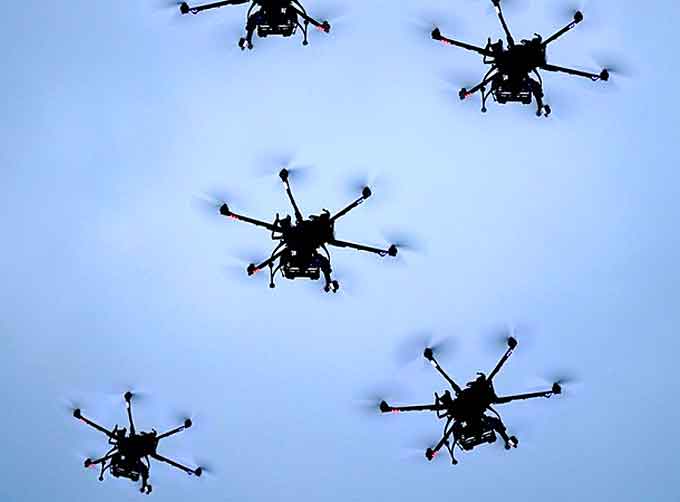
Drone swarms, or more than three drones in a single area, have been demonstrated in action in modern military settings for surveillance and delivery.
Pilots who operate more than one drone at a time can expand their reach and impact to an area, whether to support disaster response and recovery, drop contraband at a correctional facility, distract law enforcement from their operations, or threaten the security of a military base.
No airspace is immune to drone threats.
This is why we are continually advancing DroneTracker to ensure our customers can protect their assets against the growing threat of unauthorized drones in their airspace. Our software platform detects, localizes, and tracks simultaneous drones and swarms to protect against advanced drone threats.
DroneTracker 3.5 software, which can be hosted either in the cloud or on-premise, utiziles Dedrone’s DroneDNA database to recognize and classify RF, WiFi, and autonomous drones approximately one kilometer away from a protected site.
DroneTracker 3.5 brings significant enhancements for customers.
Here’s what’s new with DroneTracker 3.5:
LOCALIZATION OF MULTIPLE DRONES AND REMOTE CONTROLS
Check out what DroneTracker 3.5 looks like when there are multiple drones coming in at once.
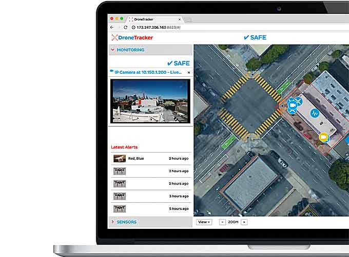
DroneTracker 3.5 uses RF Sensors and video cameras to provide simultaneous detection, including a redesigned alert screen for handling multiple alerts.
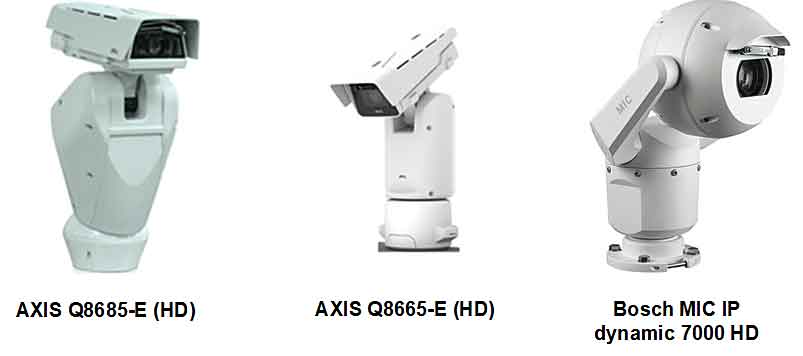
As drones maneuver through the airspace, certain PTZ cameras will now be prompted by DroneTracker 3.5 to automatically mimic the movement, providing increased visual awareness of the vehicle’s identifying features and payload.
In the case of multiple drones, DroneTracker 3.5 will prompt the PTZ camera to intelligently coordinate their behavior.
Watch how PTZ cameras follow the airspace action with DroneTracker 3.5, below:
(Learn More about DroneTracker 3.5 with Swarm Detection & Localization. Courtesy of Dedrone and YouTube. Posted on Sep 20, 2018.)
VIDEO RECORDING OF EVIDENCE VIA AUTOMATED PAN-TILT-ZOOM TRACKING OF DRONES
As drones maneuver through the airspace, certain PTZ cameras will now be prompted by DroneTracker 3.5 to automatically mimic the movement, providing increased visual awareness of the vehicle’s identifying features and payload.
In the case of multiple drones, DroneTracker 3.5 will prompt the PTZ camera to intelligently coordinate their behavior.
Watch how PTZ cameras follow the airspace action with DroneTracker 3.5 below.
(See the DroneTracker 3.5 Pan-Tilt-Zoom Camera Tracking capabilities in Action! Courtesy of Dedrone and YouTube. Posted on Sep 19, 2018.)
NEW PTZ CAMERA MODES FOR INTELLIGENT TRACKING AND DETECTION
PTZ cameras integrated with DroneTracker 3.5 have three detection and information gathering stages, which includes:
- Passive: No video detection or auto-tracking of drones
- Detection: Camera detects drones, but does not track
- Tracking: Camera actively receives positions from other sensors (i.e., RF-100 or RF-300) and automatically tracks the drone flightpath and movement
MAP AND VISUALIZATION UPDATES
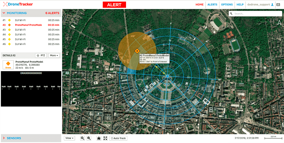
DroneTracker 3.5 now integrates a point of interest (POI) marker with a tactical overlay on the user’s map, including real-time calculation of distance and movement of multiple targets.
This POI marker helps users calculate the distance between an approaching drone and a specific point in the protected area, or a person’s location.
DroneTracker 3.5 now supports street, satellite and hybrid maps, allowing for users to view drone alerts and movement on the map of their choice.
GENERAL PERFORMANCE ENHANCEMENTS
DroneTracker 3.5 builds upon the success of DroneTracker 3, which was released in November 2017, and introduced the industry’s first airspace security solution that includes automated summary reporting for instant diagnosis of drone airspace activity.
Additional notable updates to DroneTracker 3.5 include:
- Improved overall sensor scanning and detection speeds
- Improved sensor fusion and data merging for better position calculation
- Added new detectors for more drone and remote types
- Updated user interface details, including a redesigned alert screen to handle multiple alerts simultaneously
Together, each of these updates and improvements make the Dedrone solution a reliable and accurate drone detection, classification platform for security professionals to protect critical assets.

“Security professionals are now looking beyond the single drone threat and understanding that drone pilots with intent to harm can easily coordinate efforts and use multiple drones at once to covertly spy or interrupt critical operations,” shares Joerg Lamprecht, CEO and co-founder of Dedrone.
“DroneTracker 3.5 provides forensic data of drone activity that can be used to secure protected assets, people, and infrastructure from unwanted drones.”
DroneTracker 3.5, hosted in the cloud or on-premise, uses Dedrone’s DroneDNA database to recognize and classify RF, WiFi, and non-WiFi drones.
DroneDNA
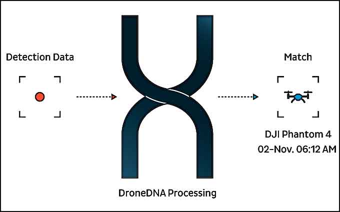 DroneDNA is a machine learning system and classification engine that recognizes drones of all kinds.
Trained on millions of images and data points, DroneDNA can distinguish between different drone models, and detect the difference between drones and other moving objects such as birds, planes, or other objects.
DroneDNA signatures are continually updated via the cloud, enabling the Dedrone system to be always up-to-date to protect against the latest threats.
DroneTracker gathers intelligence from various sensors, including radio frequency and Wi-Fi scanners, microphones, and cameras, DroneTracker 3.5 can detect drones over a mile away from a protected site and determines the communications protocol of the drone, its flight path and the location of the pilot.
Once a drone is detected, the software alerts security personnel and can be integrated to deploy a passive security measure or defeat technology.
(Learn More. It only takes 30 seconds for a drone to fly close to a company building and steal valuable data, explains Joerg Lamprecht, CEO and co-founder of Dedrone, and the damage can be immense. The drone warning system DroneTracker detects drones in real time and thus enables the security staff to take further action. Courtesy of Dedrone and YouTube. Posted on Nov 24, 2015.)


