The pilot of the rowboat Alba had a noble goal – to raise awareness and funds for the Scottish Association for Mental Health.
And he was going to row 3,400 nautical miles, from Norfolk, Va., to his home in Scotland, to do it.
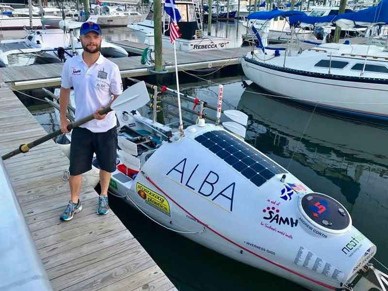
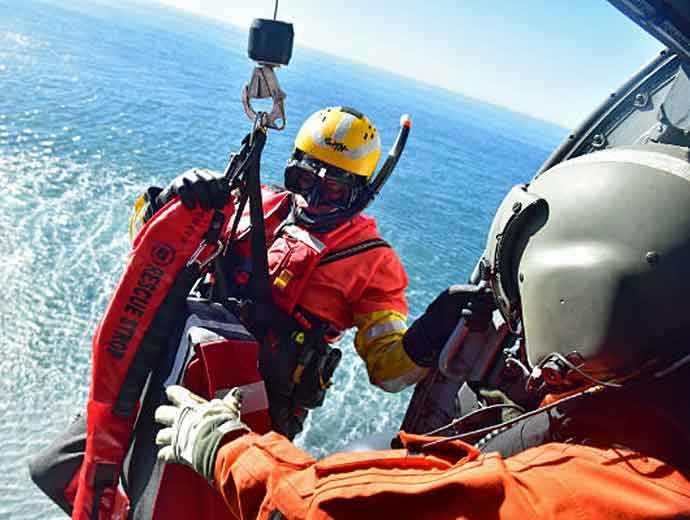
But on June 15, 2018, when he faced life-threatening danger as his boat began to take on water off Nantucket, Massachusetts, he did the right thing.
He set off his Emergency Position Indicating Radio Beacon, called an EPIRB, and a NOAA satellite picked up his distress signal.
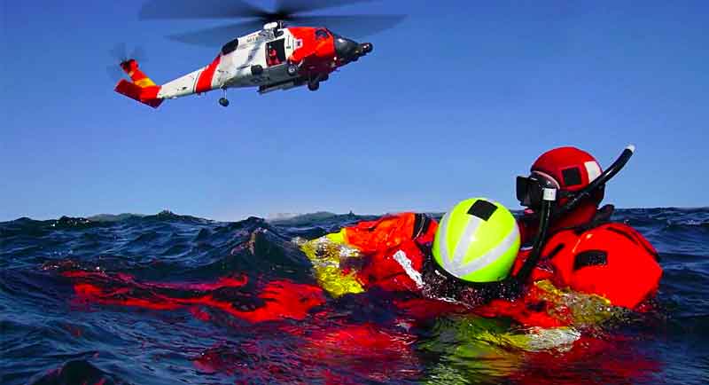
First responders soon rescued him, about 39 miles off the coast.
He was among the 340 people rescued within the United States and its surrounding waters with the help of NOAA satellites last year.
Of those rescues, 219 were from the water, 32 were from aviation incidents and 89 were on land, using personal locator beacons, or PLBs.
(Learn More. Courtesy of the International Cospas Sarsat Program and YouTube. Posted on Sep 14, 2018)
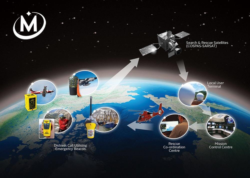
NOAA satellites are part of the global Search and Rescue Satellite Aided Tracking System, or COSPAS-SARSAT, which uses a network of U.S. and international spacecraft to detect and locate distress signals from emergency beacons aboard aircraft, boats and from handheld PLBs.

“The same NOAA satellites, critical for our weather forecasts, also play a direct role in saving hundreds of lives each year,” said retired Navy Rear Adm. Tim Gallaudet, Ph.D., assistant secretary of commerce for oceans and atmosphere and acting under secretary of commerce for oceans and atmosphere.
When a NOAA satellite pinpoints the location of a distress signal, the information is relayed to the SARSAT Mission Control Center at NOAA’s Satellite Operations Facility in Suitland, Maryland.
From there, the information is sent quickly to Rescue Coordination Centers, operated either by the U.S. Air Force for land rescues, or the U.S. Coast Guard for water rescues.
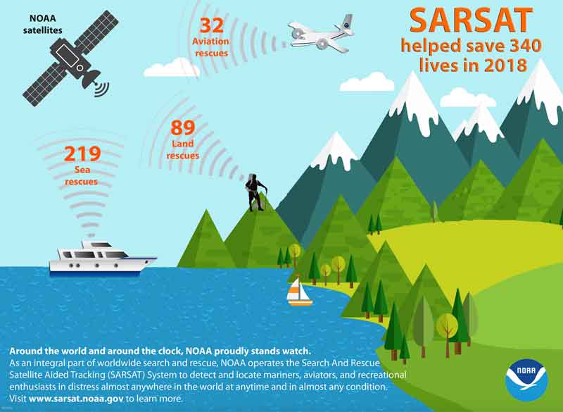
Since the program’s inception in 1982, COSPAS-SARSAT has been credited with supporting more than 43,000 rescues worldwide, including nearly 8,700 in the United States and its surrounding waters.
Beacon owners are required to register their devices online with NOAA.
The registration information often helps provide better and faster assistance to people in distress, and can guard against false alarms.
 It may also provide information about the location of the emergency and what type of help may be needed.
To Learn More about NOAA SARSAT, please visit www.sarsat.noaa.gov
NOAA’s mission is to understand and predict changes in the Earth’s environment, from the depths of the ocean to the surface of the sun, and to conserve and manage our coastal and marine resources.
Learn More…
McMurdo SmartFind G8 Wins Best Search & Rescue Solution (Video)
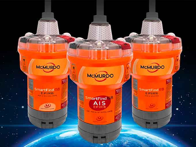
The McMurdo SmartFind G8 AIS beacon, the world’s first Automatic Identification System (AIS), Emergency Position-Indicating Radio Beacons has Quadrotech™ technology, encompassing four signal frequencies to revolutionize search and rescue (SAR) capabilities worldwide, has been selected as the 2018 ‘ASTORS’ Homeland Security Awards Program Platinum Award Winner for Best Search and Rescue Solution.
An Emergency Position Indicating Radio Beacon (EPIRB) is a safety device carried by a vessel to alert search and rescue services and allow them to quickly locate you in the event of an emergency.
When activated it transmits a coded message on the 406 MHz distress frequency which is monitored by the Cospas-Sarsat satellite system.
The alert is then relayed via an earth station to the nearest Rescue Coordination Centre (RCC).
With an EPIRB you can summon help wherever you are on the planet, subscription free, no matter how remote!
(The SmartFind G8 AIS EPIRBs offer users Accelerated Rescue via a unique combination of four search and rescue frequencies, with greater location accuracy through multi GNSS receivers and the world’s first EPIRB to contain the localized rescue power of AIS. Coupled with an unparalleled marine heritage, commitment to quality and a history of innovation, customers know they can trust McMurdo when their lives are on the line. Courtesy of the McMurdo Group, an Orolia Company, and YouTube.)
The McMurdo SmartFind G8 AIS and the Kannad SafePro AIS are the world’s first EPIRBs to include 406MHz, 121.5MHz, AIS and GNSS (better known as GPS) to accelerate search and rescue.
The unique power of these new award winning beacons is in the flexibility and additional tracking capabilities long demanded by maritime customers.
This will further reduce rescue times by combining the global location power of 406MHz with the localized rescue capacities of AIS, first introduced to the world in McMurdo’s AIS MOB range.
Only the SmartFind G8 AIS EPIRB combines 406MHz, 121.5MHz, AIS and Global Navigation Satellite System (GNSS, including GPS) technologies to strengthen the full Alert, Locate, Track and RecoverSAR process.
The dedicated 406MHz frequency signal Alerts professional SAR organizations about ships, aircraft and persons in distress.
Multiple GNSS receivers – GPS, GLONASS and Galileo satellites –Locate and Track the distress signal, while AIS and 121MHz frequencies support local homing and Recovery.
This solution engages local neighboring vessels, as well as professional SAR agency’s by delivering faster location detection, improved data accuracy and advanced tracking capabilities, to vastly improve the likelihood of a speedy and successful rescue at sea.
Other Features Include, 10-year battery life, false activation protection, a ruggedized base, and it is compliant with the US emergency hands free transport mandate.
Orolia’s McMurdo Brand Takes Platinum in the 2018 ‘ASTORS’ Homeland Security Awards Program
Orolia
-
Best Search and Rescue Solution
-
McMurdo SmartFind G8 AIS EPIRB
-
*Orolia was also a 2017 ‘ASTORS’ Award Winner
The Annual ‘ASTORS’ Awards Program is specifically designed to honor distinguished government and vendor solutions that deliver enhanced value, benefit and intelligence to end users in a variety of government, homeland security and public safety vertical markets.

The 2018 ‘ASTORS’ Awards Program drew an overwhelming response from industry leaders with a record high number of corporate and government nominations received, as well as record breaking ‘ASTORS’ Presentation Luncheon Attendees, with top firms trying to register for the exclusive high – end luncheon and networking opportunity – right up to the event kickoff on Wednesday afternoon, at the ISC East registration!
Over 130 distinguished guests representing National, State and Local Governments, and Industry Leading Corporate Firms, gathered from across North America, Europe and the Middle East to be honored among their peers in their respective fields which included:
 The Department of Homeland Security
- The Federal Protective Service (FPS)
- Argonne National Laboratory
- The Department of Homeland Security
- The Department of Justice
- The Security Exchange Commission Office of Personnel Management
- U.S. Customs and Border Protection
- Viasat, Hanwha Techwin, Lenel, Konica Minolta Business Solutions, Verint, Canon U.S.A., BriefCam, Pivot3, Milestone Systems, Allied Universal, Ameristar Perimeter Security and More!
The Annual ‘ASTORS’ Awards is the preeminent U.S. Homeland Security Awards Program highlighting the most cutting-edge and forward-thinking security solutions coming onto the market today, to ensure our readers have the information they need to stay ahead of the competition, and keep our Nation safe – one facility, street, and city at a time.

The 2018 ‘ASTORS’ Homeland Security Awards Program was Proudly Sponsored by ATI Systems, Attivo Networks, Automatic Systems, Desktop Alert, and Royal Holdings Technologies.
2018 Champions Edition
 See the 2018 ‘ASTORS’ Champions Edition – ‘Best Products of 2018 ‘ Year in Review’ for in-depth coverage of the outstanding products and services of firms receiving American Security Today’s 2018‘ASTORS’ Homeland Security Awards.’
Nominations for the AST 2019 ‘ASTORS’ Homeland Security Awards Program will officially open as of January 1st, 2019 at americansecuritytoday.com.
Enter Early to Maximize Media Coverage of your Products and Services at Kickoff, and Get the Recognition Your Organization Deserves!
And be sure to Register Early for the 2019 ‘ASTORS’ Awards Presentation Luncheon at ISC East 2019 to ensure your place at this limited- space event!


