


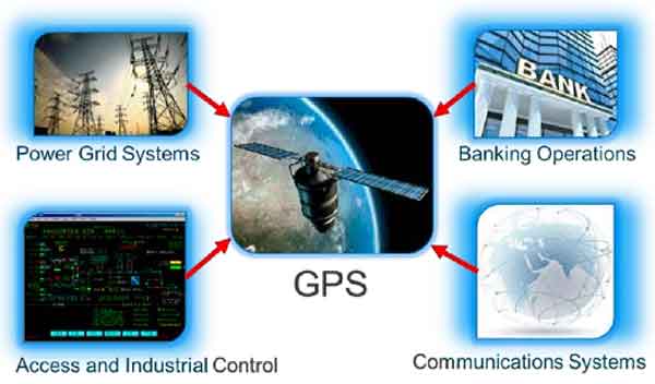
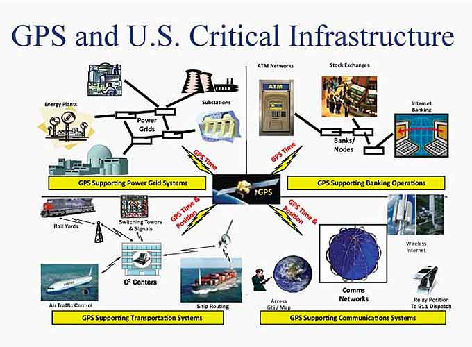
Our nation’s critical infrastructure sectors strongly rely on accurate position, navigation and timing (PNT) to function efficiently and with the reliability required to keep assets and Americans safe.
Precision timing is one aspect that is particularly important, with one microsecond level or better synchronization often being required by numerous infrastructure systems, such as the electric grid, communication networks and financial institutions.
Currently, the global positioning system (GPS) is the primary source of distributed and accurate timing information.
However, GPS’s space-based signals are low-power and unencrypted, making them susceptible to both intentional and unintentional disruption.
(Learn More about GPS and some of the varied applications that GPS provides, courtesy of Orolia, a the world leader in resilient positioning, navigation and timing (PNT), and a 2018 ‘ASTORS’ Homeland Security Awards Program Winner. Courtesy of Orolia and YouTube.)
To address GPS vulnerabilities in critical infrastructure, the Department of Homeland Security (DHS) Science and Technology Directorate (S&T), a 2018 ‘ASTORS’ Homeland Security Award Program Triple Winner, has dedicated a multi‑year program, with a multi‑pronged approach to increase our nation’s resiliency, beginning with the following steps:
Conduct vulnerability and impact assessments
- To better understand vulnerabilities at the end-user equipment level, testing and evaluation is being conducted on an array of commercial GPS receivers used within the critical infrastructure sectors.
- This will help characterize the GPS receivers’ behavior under various scenarios and identify key vulnerabilities.
- Analysis is also being performed to better understand the national impacts and consequences of timing disruptions to critical infrastructure.
- These system-level risk and impact assessments will help prioritize mitigation efforts.
Develop mitigations
- Mitigations range from implementing best practices to developing improved, more secure hardware.
- This part of the program focuses on several different types of mitigations.
- Examples include
- Improving situational awareness by developing the capability to detect and automatically alert users of jamming or spoofing events
- Working with equipment manufacturers to ensure newer product lines are more robust to existing threats
- Developing new antenna designs optimized to minimize jamming and spoofing effects on GPS receivers.
Explore complementary timing technologies
- In addition to mitigation capabilities, complementary timing technologies will be developed to reduce reliance on a single system (GPS).
- This effort is driven by National Security Presidential Directive-39 (NSPD-39) of 2004, which mandates the development of alternate PNT capabilities to augment GPS.
- Alternate timing technologies will not only provide new sources of robust timing data, but they will also hamper jamming and spoofing attempts, as having complementary timing sources enables comparison and validation of timing data.
Outreach and Education
- A key element of the program is outreach to a number of different stakeholders to educate them on threats, vulnerabilities, impacts, and mitigations.
- The equipment manufacturers are a key part of this effort, and test results will be used to engage and inform manufacturers on the need for more secure and robust equipment.
- Critical infrastructure owners and operators are also key stakeholders to educate on the current and evolving threats, best practices, and mitigations.
Engage with industry through outreach meetings and events
(Learn More. S&T is mobilizing innovation to secure our world. From sensors to cybersecurity to technology for first responders, we work with you to find tomorrow’s solutions, today. Courtesy of DHS Science and Technology Directorate and YouTube. Posted in April of 2017.)
Partnering with Industry Outreach
Industry outreach is a key component of the PNT program’s strategy, and a major event S&T hosted was the 2018 GPS Equipment Testing for Critical Infrastructure (GET-CI).
This annual event provides stakeholders an opportunity to test and evaluate equipment in a unique live‑sky GPS interference environment rarely available to the private sector.
Stakeholders include critical infrastructure GPS equipment manufacturers and critical infrastructure owners and operators.
“Many major critical infrastructure GPS equipment manufacturers attended this year’s S&T GET-CI event,” said Sarah Mahmood, DHS S&T Program Manager.
“This made it a key engagement opportunity for the PNT program to both discover and cultivate working relationships with industry, and is a critical component of the program’s strategy for transition.”
Introducing Available Technologies
In addition to informing the public of the nation’s critical infrastructure challenges, S&T also develops cost‑effective mitigation technologies for GPS interference, such as the Total Horizon Nuller (THN) antenna, which was developed in conjunction with the Homeland Security Systems Engineering and Development Institute (HSSEDI).
This antenna design is available to manufacturers through a no-cost license, and S&T has already transitioned the antenna to three companies for commercialization.
The THN antenna is a specialized low‑cost “anti-jam” antenna for fixed infrastructure applications that mitigates ground-based sources of GPS interference, to enable critical infrastructure owners and operators to deploy such antennas more widely within parts of their networks that require resilience measures, but were not critical enough to warrant significantly higher priced solutions.

“Some critical infrastructure operators have thousands of GPS antennas and receivers in their network. Widely deploying a $10,000 antenna is impractical,” explains Mahmood.
“This is especially true for the wireless communications sector, which deploys cell sites everywhere. But a low-cost antenna could be deployed at sites within the networks that need it.”
Looking to the future, the PNT program is engaging private industry to develop an “assured timing compliance framework” to strengthen the resilience of the nation’s critical infrastructure.
This framework will be a key part of the PNT program and aims to help different levels of smart and resilient receivers meet varying end-user needs in sectors, like banking and communications.
Participation in this compliance framework will be voluntary, but industry-wide adoption of this framework will enable greater PNT resilience in critical infrastructure, like the nation’s electric grids, communication networks and financial institutions.
To learn more about GET-CI, the THN antenna or S&T’s work in the area please visit Position, Navigation and Timing (PNT), or email GPS4Critical-Infrastructure@hq.dhs.gov.
DHS Science and Technology Directorate (S&T) Honored in the 2018 ‘ASTORS’ Homeland Security Awards Program

-
‘Excellence in Homeland Security’
-
Android Team Awareness Kit (ATAK)
-
‘Excellence in Homeland Security’
-
Enhanced Dynamic Geo-Social Environ (EDGE) Virtual Online Training for First Responders
-
‘Excellence in Homeland Security’
-
Flood Apex Program Flood Sensors
-
*DHS S&T is also a 2017 ‘ASTORS’ Award Winner
The Annual ‘ASTORS’ Awards Program is specifically designed to honor distinguished government and vendor solutions that deliver enhanced value, benefit and intelligence to end users in a variety of government, homeland security and public safety vertical markets.

The 2018 ‘ASTORS’ Awards Program drew an overwhelming response from industry leaders with a record high number of corporate and government nominations received, as well as record breaking ‘ASTORS’ Presentation Luncheon Attendees, with top firms trying to register for the exclusive high – end luncheon and networking opportunity – right up to the event kickoff on Wednesday afternoon, at the ISC East registration!
Over 130 distinguished guests representing National, State and Local Governments, and Industry Leading Corporate Firms, gathered from across North America, Europe and the Middle East to be honored among their peers in their respective fields which included:

- The Department of Homeland Security Federal Protective Service (FPS)
- Argonne National Laboratory
- The Department of Homeland Security
- The Department of Justice
- The Security Exchange Commission Office of Personnel Management
- U.S. Customs and Border Protection
- Viasat, Hanwha Techwin, Lenel, Konica Minolta Business Solutions, Verint, Canon U.S.A., BriefCam, Pivot3, Milestone Systems, Allied Universal, Ameristar Perimeter Security and More!
The Annual ‘ASTORS’ Awards is the preeminent U.S. Homeland Security Awards Program highlighting the most cutting-edge and forward-thinking security solutions coming onto the market today, to ensure our readers have the information they need to stay ahead of the competition, and keep our Nation safe – one facility, street, and city at a time.
The 2018 ‘ASTORS’ Homeland Security Awards Program was Proudly Sponsored by ATI Systems, Attivo Networks, Automatic Systems, Desktop Alert, and Royal Holdings Technologies.
‘ASTORS’ Champions Edition – ‘Year in Review’
Be on the lookout for the upcoming 2018 American Security Today ‘ASTORS’ Champions Edition for in-depth coverage of the outstanding agencies and companies that received American Security Today’s 2018‘ASTORS’ Homeland Security Awards.

The ‘ASTORS’ Champion Edition is published annually in December and includes a review of programs and feature details on many of the winning firms.
Nominations for the AST 2019 ‘ASTORS’ Homeland Security Awards Program will officially open as of January 1st, 2019 at americansecuritytoday.com.
Enter Early to Maximize Media Coverage of your Products and Services at Kickoff, and Get the Recognition Your Organization Deserves!

Why the 2018 ‘ASTORS’ Homeland Security Awards Program?
American Security Today’s comprehensive Annual Homeland Security Awards Program is organized to recognize the most distinguished vendors of physical, IT, port security, law enforcement, and first responders, in acknowledgment of their outstanding efforts to ‘Keep our Nation Secure, One City at a Time.’
To Learn More about the ‘ASTORS’ Awards Program, Sponsorship Opportunities and More, please contact Michael Madsen, AST Publisher at: mmadsen@americansecuritytoday.com or call 732.233.8119 (mobile) or 646-450-6027 (office).

Learn More…
Orolia PNT Solutions for Military GPS/GNSS Challenges (Multi-Video)


